

This is the real Fort Lee. On the map, I've (crudely) drawn the lines where the walls will be in a few hundred years' time.
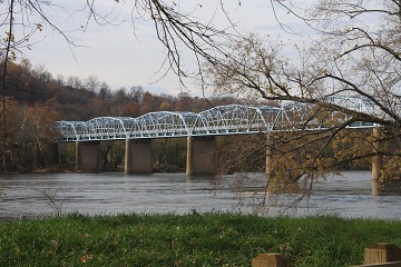
After Wess and Remi leave, they camp out near a river, surrounded by the ruins of an ancient bridge:

Quite a bit further north as our heroes near New Jerusalem, they find the Great Mound:

And here's New Jerusalem itself:

And here's Detrick:

And here's the journey, from beginning to end, with red representing Wess' flight north and the blue representing Wess' path when he returned to New Jerusalem:

1. The Varina-Enon Bridge.
2. Richmond International Airport. That's the long open space they cross and soon after, come to an old interstate. Wess looks west into Richmond from I-64.
3. Fort A. P. Hill. This is the place Wess and Remi find a wall, not unlike their own at Fort Lee. They get a bad vibe and flee.
4. The place where Wess and Remi are taken by Mountaineers/Rogues. They're camped out in one of those long valleys between trees where huge power line towers stretch toward the horizon.
5. The place where they emerge after escaping the Mountaineers' compound under Quantico.
6. The Great Mound and Southern Gates of New Jerusalem.
7. Great Falls. This is where Wess crosses the Potomac to get on the Maryland side to stay away from all the terminals:

8. As I wrote, I kept a window open with Google Maps and I scrolled north and traced a path for Wess. Sometimes I found things in his path that I could use in the book. Creeks, fields, large buildings, power stations ... here at the number eight, there was a large quarry. That whole scene with Wess falling in came from me just stumbling across it as I scrolled north toward Fort Detrick:

9. Point of Rocks bridge. This is the place where Wess and the others cross the Potomac on their return visits to New Jerusalem:
10. Leesburg, VA. The town where Pol turns left on the return trip. The group travels along Route 7 back to the Western Gates. Ditto for the military mission later on.
And that's pretty much that. Unless I get a bunch of requests for me to outline the origins of the theology of New Jerusalem, I believe I've finished with Diary of a Second Life's special features.
If you haven't bought it already, you can do get it at Smashwords HERE in multiple file formats (use coupon code EC76Q to get it for just 99¢) or at Amazon HERE.
Stick around. There's more to come, of course.
No comments:
Post a Comment